Re:Can we see the Jump Maps?
Posted: Mon Feb 15, 2010 2:40 am
I didn't see one for Herr's ridge and area, though.
Or did you just not post it.
Or did you just not post it.
Yes it's posted. Herr's Ridge is part of the Macpherson's Ridge map. It's a little hard to read in the screenshots, but the maps have been updated for the release and are easier to read.I didn't see one for Herr's ridge and area, though.
Or did you just not post it.
I think Hancock's concern (he can correct me if I'm wrong) is that the map western edge gets cut off right at the Herr Tavern location and doesn't include anything west of that point where Buford's cavalry initially opened the battle, where Confederates initiated their 1st day attacks, or where Longstreet started his march on the 2nd for positioning his troops for the 2nd's afternoon actions. Since Herr's ridge runs in a generally SW/NE direction most of the ridge SW of Herr's Tavern would not be part of the game map, including a large portion of Springs Hotel Woods and 1st day Confederate staging areas in and just west of these woods.Hancock the Superb wrote:Yes it's posted. Herr's Ridge is part of the Macpherson's Ridge map. It's a little hard to read in the screenshots, but the maps have been updated for the release and are easier to read.I didn't see one for Herr's ridge and area, though.
Or did you just not post it.
http://www.norbsoftware.com/NSDTeam/scr ... sridge.jpg
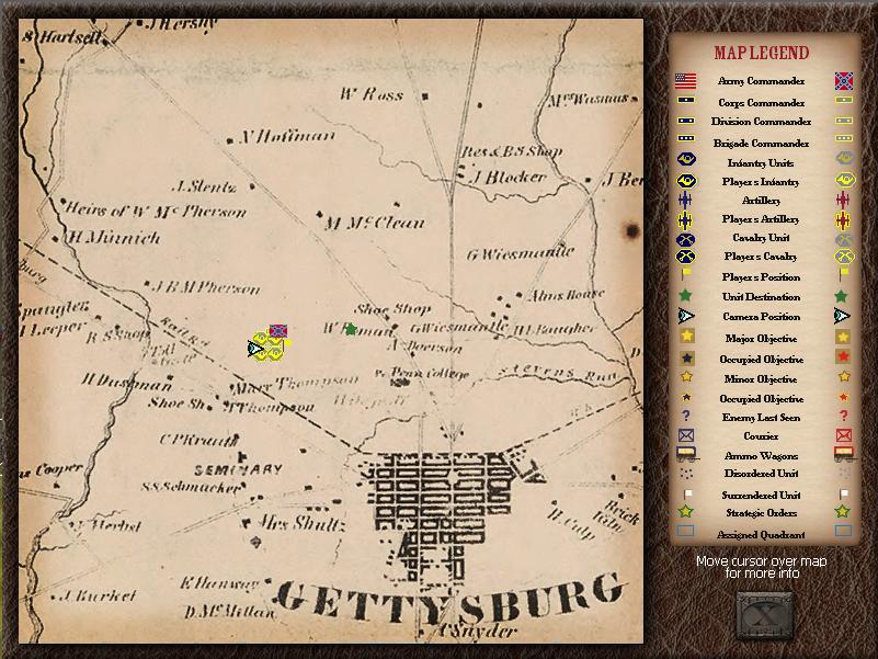
This old version of the jump map may be misleading, because the engagements you list above are all in the game.Little Powell wrote:I think Hancock's concern (he can correct me if I'm wrong) is that the map western edge gets cut off right at the Herr Tavern location and doesn't include anything west of that point where Buford's cavalry initially opened the battle, where Confederates initiated their 1st day attacks, or where Longstreet started his march on the 2nd for positioning his troops for the 2nd's afternoon actions. Since Herr's ridge runs in a generally SW/NE direction most of the ridge SW of Herr's Tavern would not be part of the game map, including a large portion of Springs Hotel Woods and 1st day Confederate staging areas in and just west of these woods.Hancock the Superb wrote:Yes it's posted. Herr's Ridge is part of the Macpherson's Ridge map. It's a little hard to read in the screenshots, but the maps have been updated for the release and are easier to read.I didn't see one for Herr's ridge and area, though.
Or did you just not post it.
http://www.norbsoftware.com/NSDTeam/scr ... sridge.jpg
Thanks LP. That's good news. Does the map extend far enough west to include Marsh Creek? I think Marsh Creek is the most west we'd need but I don't think we even have to go quite that far west to still be good to go for the game.Amish John wrote:This old version of the jump map may be misleading, because the engagements you list above are all in the game.Little Powell wrote:I think Hancock's concern (he can correct me if I'm wrong) is that the map western edge gets cut off right at the Herr Tavern location and doesn't include anything west of that point where Buford's cavalry initially opened the battle, where Confederates initiated their 1st day attacks, or where Longstreet started his march on the 2nd for positioning his troops for the 2nd's afternoon actions. Since Herr's ridge runs in a generally SW/NE direction most of the ridge SW of Herr's Tavern would not be part of the game map, including a large portion of Springs Hotel Woods and 1st day Confederate staging areas in and just west of these woods.Hancock the Superb wrote: Yes it's posted. Herr's Ridge is part of the Macpherson's Ridge map. It's a little hard to read in the screenshots, but the maps have been updated for the release and are easier to read.
http://www.norbsoftware.com/NSDTeam/scr ... sridge.jpg
The map isn't that misleading, as it still shows the actual game area, we just updated the actual look of the map. Herr's tavern is JUST barely on the map and is the westernmost point in this game area. Marsh Creek -- and locations SW of Herr's Tavern -- is not in the game map for Day 1.Little Powell wrote:Thanks LP. That's good news. Does the map extend far enough west to include Marsh Creek? I think Marsh Creek is the most west we'd need but I don't think we even have to go quite that far west to still be good to go for the game.Amish John wrote:This old version of the jump map may be misleading, because the engagements you list above are all in the game.Little Powell wrote: I think Hancock's concern (he can correct me if I'm wrong) is that the map western edge gets cut off right at the Herr Tavern location and doesn't include anything west of that point where Buford's cavalry initially opened the battle, where Confederates initiated their 1st day attacks, or where Longstreet started his march on the 2nd for positioning his troops for the 2nd's afternoon actions. Since Herr's ridge runs in a generally SW/NE direction most of the ridge SW of Herr's Tavern would not be part of the game map, including a large portion of Springs Hotel Woods and 1st day Confederate staging areas in and just west of these woods.
That should still be good because all you're really excluding are the very initial early morning cavalry holding actions. All the really major actions happened on the east side of Herr Ridge. There's an awful lot of terrain on those four maps.Amish John wrote:The map isn't that misleading, as it still shows the actual game area, we just updated the actual look of the map. Herr's tavern is JUST barely on the map and is the westernmost point in this game area. Marsh Creek -- and locations SW of Herr's Tavern -- is not in the game map for Day 1.Little Powell wrote:Thanks LP. That's good news. Does the map extend far enough west to include Marsh Creek? I think Marsh Creek is the most west we'd need but I don't think we even have to go quite that far west to still be good to go for the game.Amish John wrote: This old version of the jump map may be misleading, because the engagements you list above are all in the game.